Geological analysis softwareのメーカーや取扱い企業、製品情報、参考価格、ランキングをまとめています。
イプロスは、 製造業 BtoB における情報を集めた国内最大級の技術データベースサイトです。

Geological analysis software(3d) - メーカー・企業と業務用製品 | イプロスものづくり

Geological analysis softwareの製品一覧

1~2 件を表示 / 全 2 件

表示件数

Utilizing borehole data with Surfer

Utilizing borehole data in Surfer

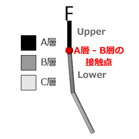
If you want to confirm the layering of strata (stratigraphy), age, mineralization layers, etc., the Drillhole layer in Surfer can realistically reproduce your well data as a true 3D display, along with the contents included in the data (e.g., contaminant concentrations, mineralization concentrations, results of quantitative analysis, geophysical characteristics, etc.). It is also possible to display the path of the borehole, data points, and intervals, as well as color-coding based on the values of the data. In the latest version, it has become possible to create contact points within the drill hole based on keywords (such as lithology names) and data queries (such as SWV: seismic-while-drilling and CPT: Cone Penetration Test data). Visualizing subsurface layers has never been easier!

  • drillm_02-ezgif.com-optimize (1).gif
  • drill_59.png
  • Earth Sciences
  • Distance measuring device
  • Other measurement, recording and measuring instruments
  • Geological analysis software

ブックマークに追加いたしました

ブックマーク一覧

ブックマークを削除いたしました

ブックマーク一覧

これ以上ブックマークできません

会員登録すると、ブックマークできる件数が増えて、ラベルをつけて整理することもできます

無料会員登録

"Surfer" for visualization of mineral deposits and planning of mining operations for the mining industry.

2D and 3D topographic mapping software to support resource quantity evaluation in mining.

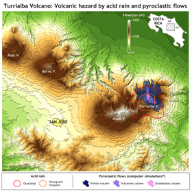
In the field of mining, accurately understanding resource quantities is essential. To conduct precise resource evaluations, it is necessary to accurately visualize and analyze terrain data from both the surface and underground. Inaccurate terrain data or inappropriate analyses can lead to underestimation or overestimation of resource quantities, significantly impacting mining plans and investment decisions. Surfer supports resource evaluations by creating accurate 2D and 3D maps and models from various data sources, including LiDAR data. 【Use Cases】 - Visualization of mineral deposits - Planning of mining operations - Estimation of resource quantities 【Benefits of Implementation】 - Realization of accurate resource evaluations - Improvement of mining efficiency - Enhanced accuracy of investment decisions

  • surfer_TurrialbaVolcano-400x402-1.png
  • logo_jp_surfer_350.png
  • Earth Sciences
  • Distance measuring device
  • Other measurement, recording and measuring instruments
  • Geological analysis software

ブックマークに追加いたしました

ブックマーク一覧

ブックマークを削除いたしました

ブックマーク一覧

これ以上ブックマークできません

会員登録すると、ブックマークできる件数が増えて、ラベルをつけて整理することもできます

無料会員登録